National Capital Planning Commission: 2013 Year in Review
DDIS’ aerial documentation, captured as part of the DC height study, has been graced with the cover of the NCPC: 2013 Year in Review annual report.
Click here to view NCPC’s digital version ► http://www.ncpc.gov/yearinreview/
The Washington Post
Arlington School Aims to Launch Satellite by Moira E McLaughlin
Published: May 24th, 2013
“Last week, the students, with the help of computer teacher Melissa Pore, conducted the first test of their satellite, which is called a CubeSat. It weighs three pounds and is about the size of a tissue box. They attached the satellite to a helium-filled weather balloon that was connected by rope to a truck. The students watched as the engineers who brought the weather balloon loosened the ropes, allowing the balloon to fly like a kite. The satellite rose 800 feet into the air. (That’s almost 250 feet higher than the Washington Monument.) Then the engineers brought the balloon and satellite back down.” – McLaughlin
Read the article: http://www.washingtonpost.com/lifestyle/kidspost/arlington-school-aims-to-launch-satellite/2013/05/24/dd1fa14c-c2ff-11e2-9fe2-6ee52d0eb7c1_story.html
Photography: Moira E. McLaughlin/The Washington Post
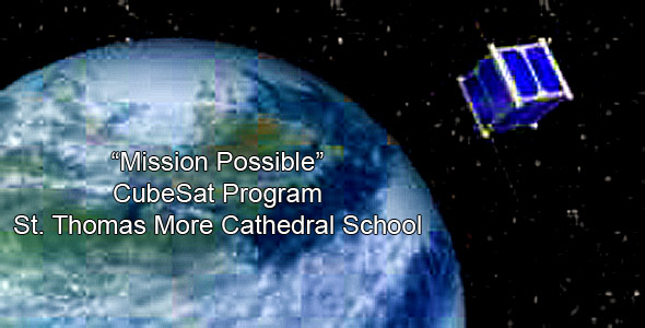
Digital Design & Imaging Service, Inc. partnered with NASA and St. Thomas More Cathedral School to loft a Cube Satellite (CubeSat) on its surveillance aerostat this morning. This launch was the first step of many, which are needed before this elementary school can reach its ultimate goal of launching a satellite in space. Once complete, this elementary school will be the first in the United States to accomplish this incredible task.
Photography by STM School
http://stmschool.org/
First Elementary School in United States to Launch Satellite
St. Thomas More Cathedral School First Step in “Mission Possible” Program
Surveillance Aerosat Launch
St. Thomas More Cathedral School (STM) will take its first step in the Mission Possible Project – STM-1 — by launching the surveillance aerosat. On May 22, 2013 at 9am in the school’s parking lot, Student Mission Specialists will conduct a series of high altitude tests of the CubeSat. Our mission is four fold: the CubeSat will be lifted to an altitude of approximately 300 feet by the surveillance aerosat; the CubeSat will operate under its own power; the telemetry and command link be established and verified which is the communication between the satellite and ground station; and the onboard cameras — both the Earth Observation Camera and the Asteroid Location Camera — will take test images.
- What: Surveillance Aerosat Launch of St. Thomas More Cathedral School’s “Mission Possible” Satellite program
- When: May 22, 2013 at 9:00am
- Where: St. Thomas More Cathedral School Parking Lot, 105 North Thomas Street, Arlington, VA
- ***Students, Faculty and Parents will be available for interviews. Media will be able to take photos and live video.
- Photo Illustration by STMSchool.
- Video: News Channel 8 Report
- St Thomas More Cathedral School Press Release published May 17th, 2013.
GOVERNMENT OF THE DISTRICT OF COLUMBIA
Executive Office of the Mayor
Office of Communications
PRESS RELEASE
FOR IMMEDIATE RELEASE: Tuesday, April 30, 2013
CONTACT: Doxie McCoy (EOM) 202.727.9691; doxie.mccoy@dc.gov
Tanya Stern (OP) 202.442.7635; tanya.stern@dc.gov
Mayor Vincent C. Gray Announces District’s Consultant Teams for Study of City’s Building Heights
Height Master Plan to Examine Impacts of Height on Federal & Local Interests
(WASHINGTON, D.C.) – Mayor Vincent C. Gray today announced the consultant teams selected by the District to support the development of the congressionally requested Height Master Plan for the District of Columbia. House Oversight Committee Chairman Rep. Darrell Issa (R-Calif.) asked the District and the National Capital Planning Commission (NCPC) to create a joint Height Master Plan that will explore the impact of strategic changes to the federal Height of Buildings Act of 1910 (The Height Act) and determine the extent to which the Height Act continues to serve both the federal and District government interests. The Height Act is a federal law that imposes restrictions on the height of all buildings within the District’s boundaries.
“I am excited to have these experienced and highly regarded experts provide their knowledge and experience to help us take this once-in-a-century opportunity to strategically examine how we can preserve this city’s unique and iconic skyline while exploring how to ensure the Height Act continues to meet federal and District interests,” said Mayor Gray.
In response to the committee’s request, the District and NCPC developed a joint proposal that is guided by the following principles:
Ensuring the prominence of federal landmarks and monuments by preserving their views and setting;
Maintaining the horizontality of the monumental city skyline; and
Minimizing the negative impacts to nationally significant historic resources, including the L’Enfant Plan.
Additionally, the study will consider local economic-development goals as well as federal interests such as security, local community input, compatibility with surrounding neighborhoods and other factors.
The D.C. Office of Planning (OP) is leading the District’s efforts in partnership with NCPC on the study. The District has contracted consultant services for two studies:
Economic Feasibility Analysis that looks at the effects or limitations of construction costs at various height-level alternatives and an economic projection of the consequential effects of changes in building height at the same height alternatives. The consultant team is led by Partners for Economic Solutions (PES), a Certified Small Disadvantaged Business with extensive experience in modeling development feasibility and the effect of zoning as well as economic and fiscal impact analysis. PES is being supported by Structura, Inc., an expert in the design, analysis and investigation of building structures in the D.C. region, and the James G. Davis Construction Corporation, which is providing cost estimates. “This critical issue will affect the city’s livability in the coming decades,” said Anita Morrison, Principal of PES. “PES is excited to be providing the economic perspective.”
District of Columbia Height Master Plan Modeling Analysis to create design studies of varying building heights in areas throughout the District to understand the impacts they could have to the city’s character. The modeling study team is led by Skidmore, Owings and Merrill LLP – (SOM) one of the leading architecture, interior design, engineering, and urban-planning firms in the world, with extensive experience with D.C. projects. The SOM team also includes CyberCity 3D, Inc., a leader in 3D geospatial building generation which created and will update 3D GIS data for buildings in the District; Digital Design and Imaging Service Inc., which will provide aerial imaging and viewshed analysis; and AMT, LLC Consulting Engineers and Land Surveyors and Capital Pixel, both D.C. Certified Business Enterprise (CBE) and Small Business Enterprise (SBE) companies that will provide 3D modeling and rendering services. “We see this study as a centennial opportunity to cast the next vision for the District of Columbia,” stated Rod Garrett, FAIA, Director of SOM’s D.C. Office. “From L’Enfant’s original plan of 1791 and the Height Act of 1910, this analysis should guide us through the next 100 years.”
NCPC has contracted with AECOM, an interdisciplinary firm with expertise in urban design and planning in the Washington area, to develop case studies and compile best practices from around the world for managing building heights in thriving capital cities.
NCPC and OP will host public meetings starting in May to present and gather public feedback on the Height Master Plan. NCPC (composed of presidential appointees and representatives from the District of Columbia, federal agencies and Congress) will vote on the plan’s recommendations. Recommendations will go to Congress this fall. Please visit www.ncpc.gov/heightstudy for more information, public meeting dates, videos and opportunities for the public to sign up for updates and to comment online.
The Height Act is a federal law that can be modified only through congressional action. Any changes to the law proposed by Congress will not pre-empt local decisions by the District government about whether and when any changes to building heights would occur. The District would undertake amendments to its Comprehensive Plan and then initiate any zoning changes deemed appropriate through its normal processes, including substantial public input, to respond to any congressional modifications to the Height Act.
http://mayor.dc.gov/release/mayor-vincent-c-gray-announces-districts-consultant-teams-study-citys-building-heights
Washington Business Journal
Want permission to shoot aerial photos, video? Prepare to be patient. by Michael Neibauer, Staff Reporter
Published: Apr 6, 2012, 6:00am EDT
“In 2004, while planning the redevelopment of D.C.’s 10-acre convention center site, developer Hines Interests LP purchased a then-fairly recent aerial stock image from a photographer. The company relied on those aerial photos for years.Then last year, Hines tried something new as it sought aerial images of its CityCenterDC construction site. It hired Falls Church-based Digital Design & Imaging Service Inc. to capture the site from an aerostatic balloon.” – Neibauer

Falls Church News-Press | FCNP.com
F.C.’s DDIS Inc. Hired to Analyze Area for New Building in San Francisco by Sally D. Cole
Published: Tuesday, May 29 2012 07:57:23 PM
“Developers of the tallest building in the United States, west of the Mississippi, have hired Falls Church-based Digital Design & Imaging Service Inc. to analyze and document the potential views. The building, which is being designed by Pelli Clark Pelli Architects, is located in the San Francisco Business district near Mission Street. DDIS was hired for their proprietary surveillance aerostat balloon and optics technology.” – Cole
http://fcnp.com/2012/05/29/fcs-ddi-inc-hired-to-analyze-area-for-new-building-in-san-fransisco/
The New York Times Magazine
Inside Tri-fold Photograph used in Advertisement by Extell Development for One57
Published: December 2011
“Check out our tri-fold photograph on the inside cover of the New York Times Magazine.”
National Geographic News
One World Trade Center: Virtual View From the Top by Chris Combs
Published September 9, 2011
“When the 1,776-foot-tall (541-meter-tall) One World Trade Center tower is completed in 2013, this will be the view from its observation floor…The altitude is too low for helicopters and too high for cranes, and restricted airspace after 9/11 has kept commercial airliners away from lower Manhattan. By creating this image for architects, Westergard hopes ‘to help [1 WTC] become one of the best buildings possible.'” – Combs
http://news.
Specializing in aerial photography, viewshed analysis, visual impact surveys, and balloon tests and drone tests for marketing, zoning, site planning, and architectural design.
Try Our Project Planner:
Need to understand your views?
Contact Us Here:
Reach out. Let us show you how we can help.